
Urban populations are increasing. In 1800, only 2% of the world’s population lived in cities while in 2007 more than half of us lived in cities. Today, the total urban population is growing by a half million each week. This means that, in 2030, 60% of people on Earth will live in urban regions1.
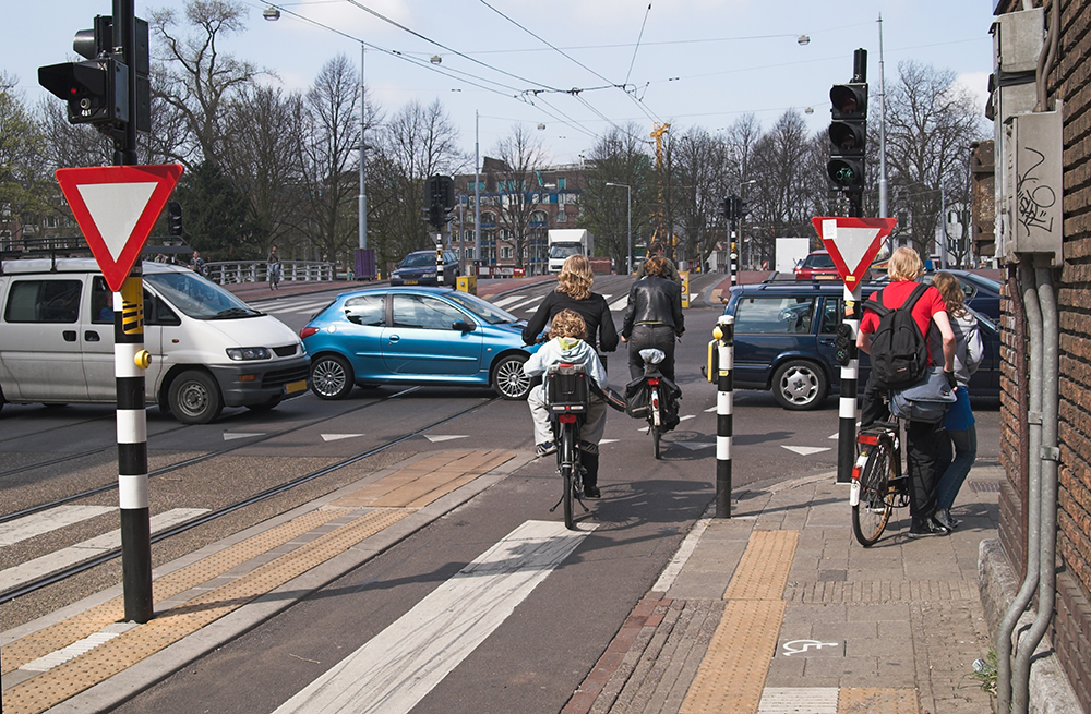
Due to urbanisation, the pressure on public space is increasing2. It is a challenge for cities to plan different activities such as living, recreation, mobility, leisure, retail and production and meet societal goals at the same time - to provide an attractive and healthy living environment and sustainable, safe and accessible transportation for all in line with the United Nations Sustainable Development Goal #11: to make cities and human settlements inclusive, safe, resilient and sustainable.
Changing mobility
Meanwhile, three important trends are changing urban mobility:
- Digitalisation enables platforms to provide new forms of mobility, such as Mobility as a Service (MaaS) and rapid introduction of new (shared) mobility modes3.
- Automation of vehicles and connected mobility will alter the role (and responsibility) of the driver4. The most committed companies in the industry are targeting several different primary use cases including ride-hailing, also referred to as robotaxis5,6.
- Electrification of mobility will lower emissions of air pollutants and, at lower speeds, noise and the cost structure of mobility7.
These trends, and especially the combination of all three, will affect the mobility proposition and therefore the way people move around in the city. If managed well these trends could lead to less car ownership, fewer car trips and therefore less use of space, cleaner air and a better living environment. Without regulation, however, these new technologies will lead to increased car usage, congestion and use of urban space8,9.
Digital city twins with urban strategy
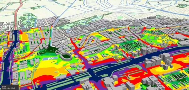
Urban planning is time consuming, not only to get all stakeholders involved, but also to assess various scenarios on multiple indicators according to (inter)national laws and regulations. The Urban Strategy10 architecture developed by TNO integrates a large number of data resources and calculation models for analysing different scenarios.
An event service bus and a data store for sharing data between computational models is the basis of the infrastructure. Various computational models are able to read and write to the data store and publish and subscribe to events11. Results of calculations can be visualised in real time in various (web) interfaces.
Current models in Urban Strategy are covering and integrating:
- Transportation demand: the number of trips per mode, based upon activities per traffic zone;
- Multimodal assignment to the transportation networks, including road traffic, public transport, cycling and shared mobility;
- Air quality emissions and concentrations, based upon road traffic characteristics, fleet composition, local topology, meteorology, background concentrations and other sources;
- Noise emissions, propagation and impact: based upon traffic characteristics, topology (shielding objects), road surface types, locations of dwellings;
- Energy usage of mobility: expected electricity demand, including public transport, impact on the power grid (grid congestion), impact of local renewable sources.
By making these models much faster than commercial off-the-shelf solutions, Urban Strategy allows interactive planning of urban space, mobility, environment and energy. Further extensions are foreseen in applying open standards and open-link data for data collection and sharing.
Example: Amsterdam
The city of Amsterdam and TNO started a long-term strategic cooperation to address the challenges of urban planning and integrated mobility planning, to jointly identify new challenges and bottlenecks, and to develop and use Urban Strategy to assess, monitor and evaluate system interventions. In other words: close the ‘learning cycle’ and validate assumptions with (real-time) data.
One application in Amsterdam is to support the planning of the reconstruction of the Zuid-As, the business district of Amsterdam. The challenge there: keep the accessibility and livability of the area up to standards during the long period (10 years) of (re)construction. Another challenge is the urgent maintenance of the bridges and quays in the city12. With Urban Strategy the city assesses the impact on traffic and accessibility of works on the 1,600 bridges, 600km of quays and banks, and five traffic tunnels. With the very high-speed performance of the instrument, the city is able to optimise the planning in order to keep the city moving.
Impact of shared mobility and mobility hubs
The Municipality of Amsterdam has asked TNO to explore options for shared mobility: determining optimal parameters, availability, spatial distribution, expected use of shared mobility and its effects (e.g. spacial gains). The aim of the municipality is to reduce car ownership and increase the share of sustainable and/or active modes of transportation such as public transport, walking and cycling. Free-floating shared cars have been added as an additional modality in Urban Strategy.
Data from shared mobility providers is used to validate the model. Various policy options (e.g. availability, pricing) have been modelled. Scenarios to implement shared mobility in the city of Amsterdam have been simulated in terms of number of cars, number of trips per car and impact on freeing up public space.
Understanding choice behaviour
To be able to simulate the impact of municipal policies, infrastructure investments and other interventions in Urban Strategy, it is essential to understand the choice behaviour of travellers for existing modalities (public transport, car, bicycle) and to understand the adoption of new modalities and concepts (such as shared mobility, micromobility, MaaS). Discrete choice models (DCM) that are used to predict choice behaviour use utility functions that describe the generalised costs for different options. Research focuses, among other things, on: the utility functions of new forms of mobility (e.g. shared mobility)13 and active mobility14, the utility of not travelling (working from home) and the possibility to include aspects other than time, cost and comfort - such as reliability or the social status of a modality. Finally, the influence of other forms of payment (for example, out of pocket versus subscriptions) on the price experienced by users is being studied.
New indicators: focus on wellbeing
Traditionally, mobility and infrastructure planning is focusing on the efficiency of the transportation system. Nowadays, more and more authorities tend to take other factors into consideration, including the distribution of impact on communities. TNO has carried out an initial exploration commissioned by the Dutch Ministry of Infrastructure and Water Management on indicators for ‘broad prosperity’ in the mobility domain15. The next step is to make these indicators applicable for ex-ante (based on forecasts) assessments. In addition, a further deepening of the possible impact is necessary by mapping the spatial and target group distributions of these indicators. This allows us, for example, to provide insight into who will reap the benefits of an investment in terms of improved accessibility – and where the disadvantageous consequences will have an impact, e.g. due to extra environmental pressure.
Conclusion
 Digital City Twins, built with TNO Urban Strategy, combine data and predictive models and support cities to shape their valuable public space and optimise on wellbeing for all communities. TNO is seeking collaboration with public authorities, private parties and research institutes to integrate knowledge on mobility and planning to help improve life in cities worldwide.
About the Author:
Jeroen Borst is cluster manager societal impact for accessibility and liveability at TNO [email protected]

")
")
")