
Canadian researchers Olivier Quirion-Blais, Martin Trépanier and André Langevin have developed an algorithm to determine the most efficient routes for snow ploughs and gritters.
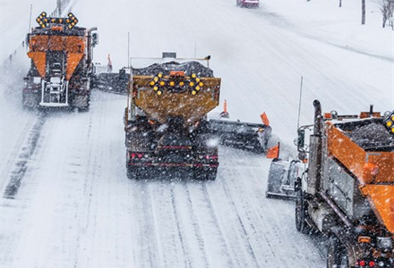
Snow plough routing has always been something of a ‘black art’: to direct a fleet of show plough to clear priority roads without having the same road cleared several times while others are left untreated.
Increasingly, GPS is being used to track the routes the clearing vehicles have taken but until now it has not been possible to take the next step – to use GPS to individually route snow clearing vehicles. Now, however, a team of researchers at the centre for inter-university research and transport logistics (CIRRELT) and Polytechnique Montréal are developing algorithms to overcome these problems.
For many years the ITS Industry and motorists alike have recognised that GPS is an excellent tool for determining the most efficient route from one location to the next. It is relatively straightforward to calculate the shortest and quickest of the available routes to get a single vehicle from one known point to another. In comparison to that, the routing problem for snow ploughing and de-icing is far more complicated.
Instead of having to compute the path from a starting point to a destination for one vehicle, it is necessary to compute the paths of all available vehicles to cover the required road network. “From a mathematical point of view, the first problem is called the shortest path problem and the latter is called the arc routing problem. More precisely, we are dealing with the subclass of the rural postman problem, which means that in the network, some roads must be serviced while others may only be traversed if needed,” said André Langevin.
To overcome this problem a set of routes, one for each vehicle, is needed. In order for it to be a feasible solution, it must cover all the required arcs while respecting certain constraints. “With the exception of some specific cases, most of these problems are deemed very hard to solve, which means that most of the real life scale problems could not be solved to optimality within years of computer calculation. In reality the snow would have melted before the computer calculated the optimum route to clear it,” said Olivier Quirion-Blais.
Fortunately, there exist some methodologies that can generate good, but not necessarily optimal solutions far more quickly. One of these methodologies, called metaheuristic, has been used by the researchers as the basis of their algorithms.
Before a metaheuristic solution can be developed, the conditions of the problem have to be established and in order that these are realistic, a case study was undertaken. The data used is from a small city in northern Quebec, Canada. The road network consists of about 260km of roadway which the local authority divides into four classes of priority for snow clearing purposes: priority one is the highest, three is the lowest and those classed as priority four are only cleared if vehicles are available after the others have been treated.
The network mixes both urban and rural characteristics. The urban part is a dense grid with mainly four-way intersections as opposed to the rural part where there are mainly long stretches of road and three-way intersections. A similar situation applies to many small cities throughout Canada and beyond. The city authority has at its disposal eight vehicles which can be classified into three types - some are better equipped to treat roads farther from the depot while others are better suited to narrow city streets.
Various objectives can be considered for the design of the snow ploughing routes - one of the most frequently considered is to complete the clearing operations in the shortest time. Among other objectives that could be considered are road users’ safety, the cost of the operations or the quality of the service. The important thing when choosing an objective is to be able to measure the impact of changing the solution.
However, in most cases, all the operational constraints have to be considered while optimising the routes. For the case studied, the main constraints considered started with the partial network coverage as not all the roads need to be serviced; most of them are serviced by the local authority although national authorities also take care of some major roads. Moreover there is a network hierarchy whereby some roads are given higher priorities - such as those leading to and from hospitals or police and firefighter stations which must be serviced as soon as possible.
To achieve the task in the shortest possible time all the vehicles must have about the same workload, which has to be balanced while considering street or vehicle dependency - narrow streets must be serviced by smaller vehicles and roads farthest from the depot should be serviced by faster vehicles. Consideration also had to be given to non-directed segments where both directions of the streets can be serviced in one passage. This specially applies to de-icing but it can be applied to snow ploughing of narrow back alleys that can be serviced in either way.
Other operational considerations included avoiding left turns when ploughing as the snow discharged can block intersections, and the same applies for U-turns - for security reasons. Constraints such as precedence, periodicity or synchronisation could also be considered.
To design a good solution within reasonable time, the researchers are developing a solution based on metaheuristic which is a two phase methodology. In the first phase, an initial solution is calculated to service all the required streets.
The objective of this first phase is not to design a good solution (in fact the initial solution might not even be feasible) but rather provide a starting point for the second phase where a search process is performed. From the initial solution, simple street exchanges will be performed from one route to another. It means that one or several streets that were initially scheduled to be treated by one vehicle are transferred to be treated by another vehicle.
The rules which guide these exchanges are called operators. Each time an operator is applied, the solution is measured with respect to the objective set earlier and this modified solution may be accepted even if the objective has not improved. For example, a deteriorated solution may simply be a transition point in the process to ultimately achieve a better (although not necessarily optimal) routing.
One of the major challenges in the development process is to design operators that can search properly among the feasible solutions. These operators are designed to promote street exchanges that provide good solutions while considering the specific constraints as described above.
It is important to note that this methodology is intended to be used as a tool for decision support; logistic managers may further improve or even ignore the calculated routes. When initiating the process several parameters must be set manually in order to comply with local constraints while event-specific situations can be accommodated in real-time.
One of the main advantages of using such methodology lies in the fact that it provides logistics managers with a new perspective. They can use their knowledge and experience to adapt the results to local requirements. Globally, designing the routes with the algorithm can results in significant savings in time.
Among other perspectives, this methodology can also help to test various scenarios such as the impact of the loss (or addition) of a vehicle on the ending time of the operations. More immediately it would allow real-time modification of the actual fleet routing if, for example, one vehicle breaks down or is slowed by the traffic. This methodology could quickly design a new routing plan taking into account the current vehicle availability.
For real-time use, the algorithm would be installed on a computer linked to a global ITS architecture. An example of this type of architecture is shown in the graphic. GPS devices provide the current location of the vehicles. Based on the previous movements of the vehicle and the weather forecast, it would be possible to determine which roads need to be treated first. Using the current condition of the network the algorithm adapts the routing in real-time and the new routes are provided to the vehicles using a global system for mobile communications. This would allow snow plough operators to focus on driving their vehicles while followings the directions given by their in-cab GPS devices.

")
")
")
")
")

")
")
")