
By 2022, there will be an estimated 105 million connected vehicles (CVs) on the road, producing an annual data stream up to 150 petabytes (equal to 15,000 years of television content, for those of us currently glued to Netflix).
Georgia Department of Transportation (GDoT) has already installed CV technology to 1,700 of the most heavily-travelled intersections in Metro Atlanta.
The Ray is the colourful name for an 18-mile section of Interstate 85 in Troup County, Georgia. This section of the highway has developed a name for itself as a sort of proving ground for transportation technology and infrastructure. It is also a predominantly rural stretch of road.
That’s why GDoT and The Ray have a two-year joint project with Panasonic to test a Vehicle to Everything (V2X) data ecosystem there. The Cirrus by Panasonic data management platform constantly receives actionable roadway information along The Ray and transmits it between state traffic operators and V2X-equipped vehicles. The idea is that this can be implemented across the state to reduce congestion and cut CO2 emissions.
Improving safety is perhaps the most vital element, however: while just 19% of Americans live in rural areas, 46% of US highway fatalities occur there – twice the rate of urban roads.
Chris Armstrong, vice president, Cirrus/V2X at Panasonic USA, is the technical lead for the company’s partnerships with US state DoTs. His job, working with a team of software developers, designers, solution architects and engineers, is to ensure the deployment of V2X technology on routes such as The Ray.
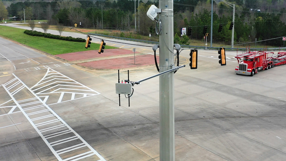
“This part of the I-85 is largely rural, there’s not a whole lot of traffic,” Armstrong tells ITS International. “We have six RSUs on the 18-mile stretch, focused at interchanges, and we have four vehicles, Ford F-250 pick-ups.”
Active deployments
GDoT has experience in deploying V2X – as does Panasonic itself. “We have a lot of active V2X deployments in the US, all using 5.9GHz,” he says. “We’re familiar with automotive integration and we’re broadcasting real-time contextual vehicle data. That’s important experience that we bring to our DoT partners. Panasonic, GDoT and The Ray all view this as a testbed for collaboration and development. The Ray is an inspirational organisation and has dedicated itself to many different, innovative projects – well beyond transportation technology.”
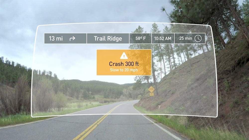
There is a lot of freight moved on the route – indeed, figures suggest that nearly half of all US truck vehicle miles travelled occur on rural roads. In addition to connected and autonomous driving, Panasonic says its system can help enable truck platooning. This is why logistics companies in particular are among the stakeholders that The Ray, GDoT and Panasonic are talking to.The partners are also setting up a stakeholder education and engagement centre. “We hope to involve a lot of creative minds,” Armstrong says. “We will demonstrate the ability to immediately detect a crash and generate an alert to warn drivers about a crash on the road ahead.”
The solution will be used to warn of other hazards too. For example, summer storms in Georgia can have a certain ‘monsoon’ quality to them. “Weather events are often very impactful to transportation safety,” Armstrong says. “We will demonstrate the ability to sense changing weather conditions such as when a major thunderstorm occurs on a highway and alert drivers immediately about the roadway conditions such as slippery roads or limited visibility. Roadway conditions can deteriorate quickly in a bad storm.”
There is an important education element to Panasonic’s involvement, with use cases demonstrated throughout 2020. “We have also built a V2X Data Visualiser tool to help people better understand the value of V2X data,” he explains. “We hope that the tool will help stakeholders use the data and envision next-generation applications made possible by V2X data and technology. That’s really the most exciting part of our business model: we want start-ups, academics – even brilliant teenagers in their basements – to use the platform to access the data and start solving transportation’s toughest problems. Openness is vital to us. We want to be a catalyst for innovation.”
Armstrong muses on the lessons that have been learned so far, and on the ones which may yet come out of the project. “GDoT has been really collaborative, really open-minded,” he says. “Most of GDoT’s fibre backhaul investment - which is extremely valuable for V2X technology installation - has been in Metro Atlanta. Most of GDoT’s V2X deployment work to date has been in areas where fibre backhaul is available. Since The Ray is in a rural area, we built an integrated cellular backhaul for the deployment on I-85 which serves as a good testing ground for how V2X technology can be deployed in more rural areas where fibre is not available.”
Rural differences
Elaine Chao, US secretary of transportation, has indicated that more funding would be available for rural infrastructure projects – a recognition that these have been neglected.
Yet since V2X deployments are often associated with urban areas, there is relatively little discussion of the differences between the two terms of problems to be overcome, what success might look like – and perhaps how expectations should be managed.
“In rural areas the value of data density is not there like urban areas where there is always traffic flow,” Armstrong begins. “There are also a lot of installation areas where power can be difficult. When you go rural, you run out of the fibre investment the state has made. There is not as much traffic so you have to be creative when thinking about the issues. There are lots of problems in cities: lots of people, lots of cars, roadways without capacity, bottlenecks when people drive aggressively. Add pedestrians into the mix and it’s very complicated.”
That’s not the case in the countryside. “In rural areas, the problems can be simple, but the solutions quite complex,” Armstrong points out. “For instance, run-off-the-road crashes are difficult to counteract and ‘random’ congestion is an issue. You need a more dynamic demand/response environment in a city, where lots of things are happening all the time. But in a rural area it is almost as though you could get bored waiting for something to happen! You need a system that can manage this. Cloud systems are good at sifting through mounds of information, constantly searching for that needle in a haystack. Maybe a crash has never occurred in a place, so you’d never expect it but a machine learning model could learn one day what conditions are most likely to produce a crash and the system could work to prevent that crash from ever occurring.”
“It all comes down to safety,” comments Harriet Langford, president of The Ray. “The data and details we will be able to gather and analyse from this system will allow transportation safety experts to study and understand vehicle crashes in a completely new way; kind of like having an airplane black box. In the future, we may even be able to intervene during or before dangerous conditions arise. That’s what this is all about. Ending highway fatalities.”
In addition, the whole project chimes with what Panasonic sees as its ‘marketplace mindset’. “It’s an innovation accelerator, an economic development tool,” Armstrong concludes. “The Ray is like an R&D shop for GDoT in some ways as it uses its philanthropy to explore the future of transportation in partnership with GDoT.”