American and European trials point to fuel and emissions reductions.
A trial by University of California-Riverside (UC-Riverside) has shown connected vehicle technology has the potential to reduce fuel consumption (and therefore emissions) by up to 18% compared with an uninformed driver.
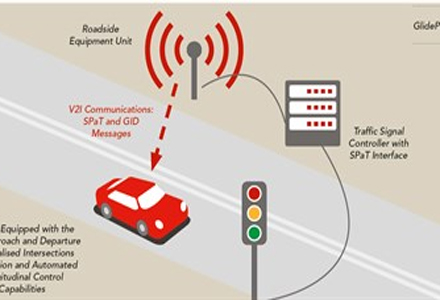
Called GlidePath, the project is part of AERIS, the section of the USDOT’s connected vehicle research program concerned with the environmental benefits the technology may provide. GlidePath fits into the Eco-signal operations section of AERIS and addresses fuel consumption and emissions reduction during the approach to, and departure, from signalised intersections.
To achieve such reductions researchers at UC-Riverside devised and tested a connected vehicle system which receives information about the phasing of the signals ahead via dedicated short range communication (DSRC). The system then calculates the required travel speeds for the vehicle to pass through the intersection in the most efficient manner.
UC-Riverside initially tested the system at the Turner Fairbank Highway Research Centre on 300m of road leading to a signalised intersection using a single car (Ford Escape Hybrid) with different drivers. Three modes were employed: driver uninformed; with driver information; and as a fully automated system.
Findings from the tests were then fed into a traffic modelling system to evaluate the potential in real world conditions.
An instrumented traffic light controller transmits signal phase and timing information 10 times a second using DSRC in order that the onboard system knows when the green phase for each direction will start and finish. Every second an onboard GPS mapping system calculates how far the vehicle is from the stop line and the direction of travel, enabling it to identify the phase timings for the appropriate direction. Using that information, the system can calculate the best speed trajectory to pass through during the green phase and update that calculation ten times a second.
In ‘advisory’ mode the system indicates the required speed on a display and creates a green band on the speedometer with the driver making all the adjustments while in automated mode it autonomously accelerates or brakes to achieve the required speed.
Four scenarios were examined:
- Travelling at its existing speed the vehicle will reach the intersection during a green phase
- The vehicle needs to accelerate to cross the intersection before the green phase finishes
- A stop is unavoidable, and
- Where the vehicle needs to slow down to preventing needing to wait at the stop line for the green phase to arrive.
In automated mode the driver touches a ‘button’ on the in-car display to confirm there is no crossing traffic (for safety) and the vehicle will then pull away from a standstill.
During the testing it was the only vehicle in the track and the lights had fixed timing, however a bend in the approach road required a DSRC repeater for the signal to reach the car at the full 300m range. Onboard the vehicle is a DSRC receiver and two GPS antennas which achieve one metre accuracy by accounting for the vehicle’s position, speed and trajectory. The UC-Riverside team lead by Professor Mat Barth created an algorithm to calculate the required speed and a basic dashboard display with a touchscreen interface.
Phases on the lights were roughly 30 seconds each for red and green (with amber in-between), and the vehicle approached to the intersection at 25mph in order to provide scope to accelerate to the 35mph speed limit in scenario two. In initial testing the vehicle could slow to 5mph in scenario three and four which in practice would annoy following drivers, so this was revised upwards to between 10 and 15mph.
To provide a complete picture, successive runs were timed to start at five-second intervals throughout the entire cycle.
The uninformed drivers’ results formed the baseline with informed drivers (green section on the speedometer) achieving a 5% average fuel saving but with a wide (18%) variation. Fuel savings averaging 20% were realised with full automation and with far more consistent results (6% deviation).
However in real world conditions the timing calculations would need to be revised depending on the length of the tailback from the stop line and there are other potential shortcomings as Osman Altan from the US Federal Highway Administration pointed out. “If everybody slowed down as in scenario four; that could have a serious impact on the efficiency of the whole corridor,” he said during a webinar.
To evaluate potential effects the system could have on fuel consumption, emissions and traffic congestion, the results were fed into a computer model of generic interchanges and also some actual corridors including the El Camino Real Road in California’s Bay Area. That section of road has 11 intersections and several were instrumented with DSCR to transmit the signal phase and timing for a separate real world trial.
In a situation where the corridor’s signals are uncoordinated, GlidePath could show a 5% to 10% reduction in fuel consumption and emissions depending on the traffic conditions. When the signals are coordinated, 13% reductions are achievable with GlidePath contributing 5%. As congestion rises the ability to speed up or slow down on the approach to the lights becomes increasingly limited while tailbacks present another level of complication for the GlidePath system.
European trials
A similar system known as GLOSA (Green Light Optimal Speed Advisory) is being trialled as part of the EU-funded
GLOSA gives the drivers advice on the best deceleration / acceleration strategy to approach the intersection along with traffic light signal phase (red / green status) and timing (‘time-to-green’).In case drivers have to stop at a traffic light, this system provides information on whether to keep the engine running or stop and restart it in time to pull away as the lights change. The Compass4D cooperative system also includes a Green priority system which can grant the green light to emergency vehicles, public transport vehicles, or also trucks (depending on the city traffic management policies) approaching the signals.
As part of the trial one of Bordeaux’s green wave routes was modelled. This covered four sets of lights which were synchronised for a ‘green wave’ at 38km/h (23.6mph). This indicated that if 20% of vehicles were equipped with GLOSA, the average saving across all vehicles using the route would be 1.6% rising to 3.4% when 80% of vehicles were instrumented.
Preliminary results show that in this city in comparison to an uninformed driver, the average fuel savings for individual vehicles range from 4.7% to more than 11% (one and three stops respectively). However, when they did not need to stop at all the uninformed drivers were slightly better (2.6%) than with GLOSA, meaning the overall average for 2,000 vehicles was a saving of 5.34%.
")
")
")
")
")


")
")
")