
The US53-STH77 intersection used as a test site in Wisconsin has a history of severe right-angle crashes
Although much of the emphasis of research into intersection management has tended to concentrate on the needs of urban locations, there remain specific issues pertaining to rural intersections which need to be addressed. Here, Rebecca Szymkowski and Greg Helgeson, Wisconsin DOT, Todd Szymkowski, University of Wisconsin-Madison, and Craig Shankwitz and Arvind Menon,
In the US, 30 per cent of all crashes occur at intersections. These crashes lead to about 9,000 fatalities per year and about 50 per cent of all traffic injuries. The USDOT is bringing technology to bear, in the form of the Cooperative Intersection Collision Avoidance Systems (CICAS) project (see article on pp.NA5-NA6 of this edition) but there remain issues especially pertinent to the rural setting.
The response is the Rural Safety Innovation Program (RSIP), a competitive programme set up by the
The primary objectives of RSIP are to: improve safety on local and rural roads with innovative approaches in which rural communities develop and design local solutions to their roadway safety problems; provide best practices and lessons learned on innovative safety technologies to assist local and rural road owners and operators in the development and implementation of infrastructure-based rural safety countermeasures that complement behavioural safety efforts; promote national awareness and interest in addressing rural safety issues; and promote the use of ITS technologies to improve safety on rural roads.
Wisconsin was one of 19 transportation agencies to be successful in gaining a grant to install an experimental Rural Intersection Collision Avoidance System (RICAS). In addition to the FHWA, the project involved the Wisconsin Department of Transportation and the universities of Wisconsin-Madison and Minnesota
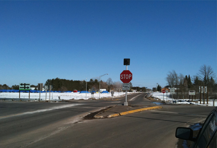
United States Highway 53 (US 53) is a divided, four-lane rural expressway which runs for 75 miles between Rice Lake and Superior in northwestern Wisconsin. The posted speed limit is 65mph. Wisconsin State Highway 77 (STH 77) traffic must stop twice, once on the initial approach to the intersection and again in the median of the divided highway, before crossing US 53.
The intersection has a history of severe right-angle crashes. From 1998 through 2004, there were 30 accidents, five of which involved fatalities and 15 of which involved injuries. The intersection crash rate was 1.9 crashes per million entering vehicles (MEV), which was higher than the expected crash rate of 0.6 crashes per MEV for the intersection.
Most of the right-angle intersection crashes occur on the far side of the intersection, when STH 77 traffic leaves the median stop location and is struck by a vehicle on US 53. Drivers on STH 77 either do not see the through vehicle or they are not selecting an appropriate gap in the US 53 traffic to make a safe crossing manoeuvre. This problem is not one of drivers failing to stop, rather drivers failing to cross safely after stopping. Driver decisions are further complicated by a large, sweeping horizontal curve of US 53 through the intersection.
Addressing historical perceptions
Historically, the perception of the crash problem at rural, stop-controlled intersections has been that drivers run the stop signs. However, the rural crash problem is not one of conspicuity or control; it is a problem with gap acceptance. The hypothesis that unsafe gap acceptance is the core problem has been proven through analyses across several US states. These analyses show that drivers stop on their first approach to an intersection, look and accept an unsafe gap which leads to a crash. If crashes occur on intersections which have higher-than-expected crash rates, there is an 80 per cent likelihood that they will occur on the far side of the intersection.In the past, the treatment of right-angle crashes on rural expressways has varied. One low-cost option includes installing additional or upgraded static warning signs in an attempt to heighten driver awareness on either or both roadways. While this maintains accessibility and is low cost, it often yields little in terms of crash reductions.
A more involved approach is to restrict certain turn movements, including full closure of the median, rendering the intersection to right-in/right-out movements only. While this may significantly reduce crashes and is relatively inexpensive, it has a significant impact on accessibility from the intersecting road.
A high-cost solution replaces the at-grade intersection with either a grade-separated bridge or an interchange with fill access via ramps. This maintains accessibility and would nearly eliminate high-speed right-angle crashes. However, the cost is often prohibitive, often reaching $10 million or more for a single location.
Some highway agencies may also consider installing traffic signals as a feasible treatment for rural expressway intersection crashes. However, Wisconsin has significant concerns regarding such an application that would be contrary to driver expectancy on a lengthy stretch of rural expressway.
The challenge is finding a treatment which balances crash reduction, accessibility and cost. The RICAS at the US 53 and STH 77 intersection may provide an answer. It provides feedback to side-street drivers about unsafe gaps on the mainline route. If the driver accepts the information provided by the driver interface, the driver on the minor road at the intersection will not choose an unsafe gap, thereby avoiding a crash.
Driver expectancy
Driver expectancy on a rural expressway differs significantly from an urban arterial. Also, vehicles on the mainline are traveling at high speeds in a rural environment. A rural expressway often looks similar to a controlled-access rural freeway but has the presence of at-grade intersections rather than interchanges.US 53 is also a relatively low-volume corridor that carries less than 10,000 vehicles per day. Both highways at this intersection also see increases in non-local traffic during the summer. Recreational drivers may get complacent when travelling on a low-volume roadway that looks like a freeway, only to encounter cross-traffic at intermittent, at-grade intersections.
The conflict between mainline high-speed vehicles and side-street drivers that select unsafe gaps causes the crash problem. The use of radar, instead of inductive loops, allows the system to track the time of arrival of the approaching vehicle continuously as opposed to capturing a "snapshot" of the approaching vehicle at discrete points on the mainline. The ability to track a vehicle trajectory improves the ability of the driver interface to accurately convey information about the state of the intersection, which improves driver acceptance and utility of the system.
Features of the RICAS
The RICAS consists of two main subsystems: the mainline surveillance and warning system and a minor road traffic detection system. On the mainline, surveillance is accomplished using three 76GHz radar systems placed along each leg to detect and estimate the time that traffic will take to reach the intersection. An LED icon-based Driver Infrastructure Interface (DII) is used to present alerts and warnings to drivers on the minor road about unsafe gaps on each approach of the mainline.As part of the study, the gap rejection behaviour of minor road drivers will be monitored both before and after the DIIs are activated. Radar-based sensors are used to determine the presence of vehicles at the stop bar of the minor road and median area. These sensors will provide information on how long a driver waits at the stop bar and which gaps were rejected.
A total of 50 volunteers are being recruited to install Radio-Frequency Identification (RFID) tags in their vehicles. Quantitative gap acceptance and rejection data will be collected from a series of RFID readers positioned throughout the intersection. The data will be collected by the central computing system over 12 months. Several video cameras have also been installed to assist with qualitative assessment of the system.
This is a second installation of the system. The RICAS was first deployed on 20 January 2010 at the intersection of US 52 and County State Aid Highway 9 (CSAH 9) in Goodhue County, MN. At the moment, the field test data is inconclusive. However, anecdotal information from users of the intersection has been positive. Human factors testing, including experimentation using instrumented vehicles (a passenger car and a heavy truck), showed that the system should improve the ability of a driver to recognise unsafe gaps and not proceed through the intersection. If the system helps a driver reject an unsafe gap, intersection safety should improve.
Potential effects of the trial
The system has been designed to function both in an infrastructure-only mode and in a cooperative mode. The design of the system will support a variety of cooperative architectures; the variation in the possible architectures is a function of where the computational system rests. In an infrastructural architecture, the infrastructure would be responsible for computing the alert and warning states of the intersection. These alert and warning states would be displayed to a waiting vehicle using Dedicated Short-Range Communication (DSRC). In a vehicle-centric architecture, the information gathered by the infrastructure-based sensors and geometric data would be provided to vehicles on the minor road; the in-vehicle computational unit would assimilate this data and locally compute the alert and warning states. If the alert and warning thresholds were exceeded, the system would activate the in-vehicle driver display.This project could have potential impacts both in Wisconsin and on the national level. If the RICAS proves to be successful and improves the safety of the intersection by reducing the number and severity of crashes, it would be an additional tool for safety engineers and others.

")
")
")
")
")

")
")
