


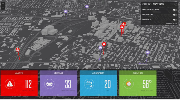
Several cities, tollways and state departments of transportation, have begun conducting early tests of aggregating not only DSRC data, but also combining weather, and other real-time streams into a common operational view. The aim is to help them understand how the aggregation of multiple live streams of data could be used to better manage traffic, but also to help warn motorists of approaching dangers.
For example, one tollway relied on Esri software capabilities to analyse streaming Internet of Things (IoT) data inputs on dashboards and maps. Aggregating not only dedicated short-range communication (DSRC) data from equipped vehicles, but also real-time weather, embedded sensors on bridges, and wind data among other live data streams. The result was that tollway staff were able to identify when certain bridges became dangerous because of icy conditions under high wind conditions.
ArcGIS Velocity allows agencies to aggregate huge streams of real-time data in the cloud and do analysis as the data streams in. Esri says this new capability will help organisations take advantage of the insights made possible by IoT with up-to-the-minute data and improved situational awareness.
These examples highlight how transportation professionals continue to explore how these new data sources and their IoT capabilities can be leveraged to provide a safer, and less congested experience on their roadways.
")

")


")
")
")
")